Hello Readers,
Early Sunday morning on the 24th, there was an 6.0 magnitude earthquake which hit around 3:20 AM near the San Francisco Bay area by Napa and American Canyon. From the U.S. Geological Survey, we can find the earthquake information.
Here we will use Python (2.7.5) to retrieve and plot the magnitudes of recent recorded earthquakes by the USGS.
Using Python to Access USGS
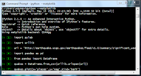
Opening the command prompt, start iPython with matplotlib module. It should look something like this: |
| Figure 1. iPython |
Then we need to import urllib, and pylab for URL access and plotting, respectively. Using the ".urlopen()" method in urllib we will open the desired URL- the significant earthquakes in the past day, updated every 5 minutes as a CSV file (here).
Code:
1 2 3 4 5 6 7 8 9 10 11 12 13 14 15 16 17 18 19 20 21 22 23 | In [1]: import urllib In [2]: url = 'http://earthquake.usgs.gov/earthquakes/feed/v1.0/summary/significant_week.csv' In [3]: quakes = urllib.urlopen(url) In [4]: for record in quakes: ...: print(record) ...: time,latitude,longitude,depth,mag,magType,nst,gap,dmin,rms,net,id,updated,place,type 2014-08-24T23:21:45.980Z,-14.5864,-73.5777,101,6.9,mww,,23,4.095,1.32,us,usb000s5x1,2014-08-25T00:50 :04.000Z,"43km ENE of Tambo, Peru",earthquake 2014-08-24T10:20:44.000Z,38.2202,-122.3128,11.3,6,Mw,146,28.8,0.03593261,0.16,nc,nc72282711,2014-08- 25T01:13:29.811Z,"6km NW of American Canyon, California",earthquake 2014-08-23T22:32:23.630Z,-32.7049,-71.3967,35,6.4,mww,,30,0.419,0.9,us,usb000s5rc,2014-08-24T11:48:3 9.000Z,"18km WNW of Hacienda La Calera, Chile",earthquake 2014-08-19T12:41:35.220Z,35.8186,-97.4718,3.46,4.2,mb,,29,0.025,0.69,us,usb000s45z,2014-08-24T06:27: 52.792Z,"7km SSW of Guthrie, Oklahoma",earthquake |
We iterate through each line with "for" and print the all the records. As you can see, the first line is the header, containing the names of the columns. In the second set of earthquake information (3rd row), we spot the early morning earthquake in California.
Organizing into DataFrame
Since the rows are quite difficult to read, we can transform "quakes" into a DataFrame, using the ".from_csv()" method in DataFrame. It generates a tidy table from which we can view the data in the output below.Code:
1 2 3 4 5 6 7 8 9 10 11 12 13 14 15 16 17 18 19 20 21 22 23 24 25 26 27 28 29 30 31 32 33 34 35 36 37 | In [5]: from pandas import DataFrame In [6]: import pandas as pd In [7]: quakes = urllib.urlopen(url) In [8]: frame = DataFrame.from_csv(quakes) In [9]: frame Out[9]: latitude longitude depth mag magType nst \ time 2014-08-24 23:21:45.980000 -14.5864 -73.5777 101.00 6.9 mww NaN 2014-08-24 10:20:44 38.2202 -122.3128 11.30 6.0 Mw 146 2014-08-23 22:32:23.630000 -32.7049 -71.3967 35.00 6.4 mww NaN 2014-08-19 12:41:35.220000 35.8186 -97.4718 3.46 4.2 mb NaN gap dmin rms net id \ time 2014-08-24 23:21:45.980000 23.0 4.095000 1.32 us usb000s5x1 2014-08-24 10:20:44 28.8 0.035933 0.16 nc nc72282711 2014-08-23 22:32:23.630000 30.0 0.419000 0.90 us usb000s5rc 2014-08-19 12:41:35.220000 29.0 0.025000 0.69 us usb000s45z updated \ time 2014-08-24 23:21:45.980000 2014-08-25T00:50:04.000Z 2014-08-24 10:20:44 2014-08-25T01:28:14.766Z 2014-08-23 22:32:23.630000 2014-08-24T11:48:39.000Z 2014-08-19 12:41:35.220000 2014-08-24T06:27:52.792Z place type time 2014-08-24 23:21:45.980000 43km ENE of Tambo, Peru earthquake 2014-08-24 10:20:44 6km NW of American Canyon, California earthquake 2014-08-23 22:32:23.630000 18km WNW of Hacienda La Calera, Chile earthquake 2014-08-19 12:41:35.220000 7km SSW of Guthrie, Oklahoma earthquake |
The 3:20 AM earthquake occured 6 kilometers North West of American Canyon in California with a magnitude of 6.0 from the 'place' variable. More recently, there was another earthquake in Peru with a magnitude of 6.9.
Plotting Magnitude
We can compare the magnitudes by using the ".plot()" function. We specify the x-axis to be the 'place' and the y-axis to be the 'mag', or magnitude, and we want a horizontal bar plot through 'kind='barh''.Code:
1 2 | In [10]: frame.plot(x='place',y='mag',kind='barh') Out[10]: <matplotlib.axes.AxesSubplot at 0x87682b0> |
 |
| Figure 2. Plot of Earthquake Magnitudes |
Great! That concludes this short post of using Python to retrieve CSV files from the USGS and basic plotting. Stay tuned for more posts!
Thanks for reading,
Wayne
@beyondvalence
Deposit Menggunakan GO Pay di Agen Judi Online terpopuler di Indonesia !
ReplyDeleteMinimal Deposit 50ribu saja, Tersedia di situs www.bolavita.fun Anda dapat menikmati berbagai jenis judi online yang tersedia ...
Info selengkapnya silahkan hubungi :
WA : +62812-2222-995
BBM : BOLAVITA
Keluaran Togel Singapura Hari Ini yang terbaru